Main menu


You are here

Risks - SF

Primary tabs

This collaboratory is focused on discussions about risks.

The mission of this collaboratory is to focus on discussions about risks.

Members

Kathy Gilbeaux mdmcdonald

Email address for group

risks-sf@m.resiliencesystem.org

Evacuation Plan 'Out the Window' When Fire Hit California Town


A building destroyed by the Camp Fire is seen in Paradise, California, U.S., November 13, 2018. REUTERS/Terray Sylvester

reuters.com - by Andrew Hay - November 17, 2018

When a “megafire” engulfed Paradise, California, officials and residents had to abandon their evacuation plans and improvise new ways to save lives, learning lessons that could help the growing number of U.S. communities at risk to wildfires.

As strong winds sent flames roaring into Paradise at 2 miles per minute, emergency personnel and locals realized their escape plans, crafted after a 2008 blaze, would not work.

“The lessons we had learned in the past kind of went out of the window due to the sheer speed and intensity of this fire,” Paradise Emergency Operations Coordinator Jim Broshears said in a phone interview.

(CLICK HERE - READ COMPLETE ARTICLE)


Country / Region Tags: 
Problem, Solution, SitRep, or ?: 

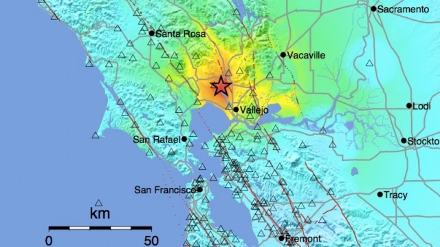
California Hit With Earthquake Of 6.0 Magnitude


huffingtonpost.com - Associated Press - by Ellen Knickmeyer - August 24, 2014

NAPA, Calif. (AP) — A large earthquake rolled through California's northern Bay Area early Sunday, damaging some buildings, igniting fires, knocking out power to tens of thousands and sending residents running out of their homes in the darkness.

Two major injuries have been reported, and hospitals have been very busy with moderate injuries, Napa Division Fire Chief John Callanan said. The 6.0-magnitude quake caused six significant fires, including at four mobile homes, Napa Division Fire Chief Darren Drake said.

(READ COMPLETE ARTICLE)

(UPDATES - SEE RELATED ARTICLE HERE)

Country / Region Tags: 
General Topic Tags: 
Problem, Solution, SitRep, or ?: 

7 Ways the Response to a Devastating Earthquake Has Changed

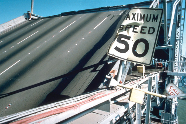
A highway destroyed by the earthquake. Photo courtesy of Flickr/Joe Lewis

Image: A highway destroyed by the earthquake. Photo courtesy of Flickr/Joe Lewis

emergencymgmt.com - September 20th, 2013 - David Raths

Most San Francisco Bay Area residents over 30 years old remember exactly where they were at 5:04 p.m. on Oct. 17, 1989, when the magnitude 6.9 Loma Prieta earthquake shook the region.

I certainly do. I was just getting ready to drive home to Palo Alto, a few miles from the editorial offices of InfoWorld, a technology publication in Menlo Park, where I worked.

(VIEW COMPLETE ARTICLE)

Country / Region Tags: 
Problem, Solution, SitRep, or ?: 

Rim Fire - Fire Tracker


View Rim Fire in a larger map

http://projects.scpr.org/firetracker/rim-fire/

Fire Tracker, KPCC's tool for following & researching California wildfires, contains fire information displayed by the California Department of Forestry and Fire Protection -- also known as CalFire -- which protects more than 31 million acres of California's privately-owned wildlands and provides emergency services in 36 of the State's 58 counties.

About the data

Country / Region Tags: 
Problem, Solution, SitRep, or ?: 

Enormous Fire Threatens Water Supply for San Francisco and Parts of East Bay

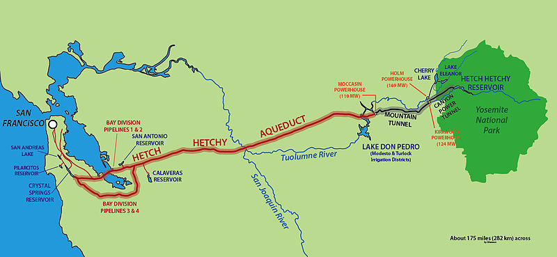
                                                 (TO ENLARGE - CLICK ON MAP IMAGE BELOW)


Hetch Hetchy Aqueduct

eastbayexpress.com - by Robert Gammon - August 23, 2013

The massive Rim Fire is closing in on Hetch Hetchy Reservoir in Yosemite National Park and is threatening the main water supply for the City of San Francisco and numerous other Bay Area communities. As of this morning, the fast-moving blaze was about 2.5 miles from Hetch Hetchy, according to a map created by the US Forest Service. If the enormous fire reaches the tinder-dry forests surrounding the reservoir, it could pollute the freshwater with huge amounts of ash. That’s bad news for San Franciscans and other communities that depend on Hetch Hetchy because the reservoir is not equipped with a water-filtration system.

(READ COMPLETE ARTICLE)

Country / Region Tags: 
Problem, Solution, SitRep, or ?: 

Researchers Use GPS Data to Speed Up Tsunami Warnings


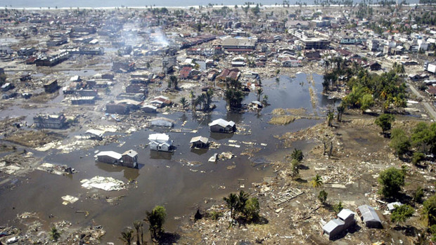
In this Jan. 2, 2005 file photo, a wide area of destruction is shown from an aerial view taken over Meulaboh, 250 kilometers (156 Miles) west of Banda Aceh, Indonesia. Researchers in the United States are hoping to use GPS data to speed up current warnings. (AP Photo/Dita Alangkara, File)

U.S. seismologists currently testing new warning system

by Andrew Pinsent - CBC News - May 5, 2012

Scientists in the United States have been testing an advanced tsunami warning system using GPS data, combined with traditional seismology networks, to attempt to detect the magnitude of an earthquake faster so warnings of potential tsunamis can get out to potentially affected areas sooner.

The prototype is called California Integrated Seismic Network (CISN), and is a collaboration between the United States Geological Survey (USGS) and The Gordon and Betty Moore Foundation, whose focus is on environmental conservation.

California Quake Test Shows Promise of New Building Code

submitted by Samuel Bendett

Homeland Security News Wire - April 19, 2012

Researchers place a model hospital on a shake table to assess the structure’s ability to withstand earthquake; in accordance with California latest building code, base isolators, which are rubber bearings intended to absorb the shock of the motion, were installed underneath the structure; the hospital passed the 6.7-magnitude and 8.8-magnitude tests with flying colors.

Last Tuesday, engineers from the University of California, San Diego conducted an ambitious and successful earthquake simulation, with what some called “boring” results.

Engineered had constructed a 5-story building, complete with a hospital operating room, an elevator, a kitchen filled with glassware. They also added a heavy air-conditioning unit to the roof. The building, built to California’s top earthquake codes, was then placed on top of a shake table, a device for shaking structural models or building components with a wide range of simulated ground motions, including reproductions of recorded earthquake time-histories.

(READ COMPLETE ARTICLE)

Water Scarcity in California's Bay-Delta Necessitates “Hard Decisions”

California's Bay-Delta water supply area // Source: usgs.gov
submitted by Samuel Bendett

Homeland Security News Wire - March 30, 2012

Simultaneously attaining a reliable water supply for California and protecting and rehabilitating its Bay-Delta ecosystem cannot be realized until better planning can identify how trade-offs between these two goals will be managed when water is limited, says a new report from the National Research Council.  Recent efforts have been ineffective in meeting these goals because management is distributed among many agencies and organizations, which hinders development and implementation of an integrated, comprehensive plan.  Additionally, it is impossible to restore the delta habitat to its pre-disturbance state because of the extensive physical and ecological changes that have already taken place and are still occurring, including those due to multiple environmental stressors.

California Struggling to Prepare Quake Early Warning System

submitted by Samuel Bendett


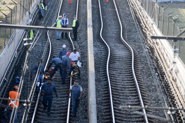
Workers fix subway lines that were damaged after an earthquake was felt in Mexico City on Tuesday, March 20. (Associated Press / March 19, 2012)

By Hector Becerra and Sam Allen, Times Staff Writers - latimes.com - March 22, 2012

The state spends a fraction of what countries like Mexico and Japan spend on their systems. One reason for the lack of interest, experts say, is that California has not experienced a catastrophic quake in more than a century.

Pages

howdy folks
Page loaded in 0.670 seconds.